|
|
|
|
|
|
|
|
|
|
|
Written
account of William Coxe, 1801
|
|
|
|
|
|
|
|
|
|
|
|
|
In
1801 William Coxe published "An Historical Tour in Monmouthshire".
His observations in Caerleon were based on visits over several
years. During just this short time he saw parts of the castle
remains being dismantled for building-stone.
His writing is very informative. A summary follows, however you
can see the full text relating to the castle by clicking
here.
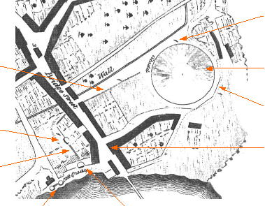
This is a section of his map of Caerleon:
|
|
|
|
|
|
|
|
|
|
|
|
|
|
 |
|
|
|
|
|
|
f
- castle wall
|
|
|
|
|
|
|
|
|
h
- castle wall
|
a
- the castle mound (citadel)
|
|
|
|
|
|
|
|
|
|
|
|
|
|
|
e
- castle walls
|
|
|
k
- tower
|
|
|
|
|
d
- the 'Gatehouse Tower'
|
|
|
|
|
|
|
g
- castle walls
|
|
|
|
|
|
|
|
|
|
c
- round towers
|
|
b
- the Hanbury Tower
|
|
|
|
|
|
|
|
|
|
|
|
|
|
|
|
|
Summary:
THE TOWER ON THE MOUND (a
on map) - On one visit
to Caerleon, Coxe observed massive foundations near the summit
of the mound. They were "not
less than twenty feet
(6m) in depth, ten
(3m)
in breadth and thirty (10m)
in length". Workmen
were in the process of separating the stones, which were then
sold to a Mr Williams who built a house with them. Residents told
Coxe that early in the 18th century the tower walls
were not less than forty feet (13m) high and that they had fallen
down in "enormous
fragments" sometime
after severe frosts in 1739.
THE MOUND - Coxe observed the situation, in the side of the mound,
where a Roman sarcophagus had been recently discovered. Constructed
of large bricks two feet (60cm) square and two inches (5cm) in
thickness it measured over six feet (2m) in length. From this
he deduced that at least some of the mound had been in place in
Roman times.
According to Coxe, the oldest inhabitants remembered dilapidated
buildings at the foot of the Mynde (see Lee's findings later)
and a flight of stone steps leading up the mound.
TOWERS NEAR THE HANBURY ARMS - He identified the Tower 'near'
the Hanbury Arms (b
on map) as part of
the castle. (This tower still exists today.) Also two round towers
or bastions (c
on map) which were
"built upon the
rocks on the verge of the river".
|
|
|
|
|
|
|
|
|
|
|
|
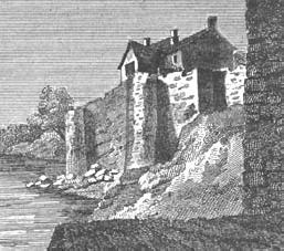 |
| Illustration
from Coxe's book. The caption says "Remains of Castle Works."
These are probably the towers ( c
) mentioned above. |
|
|
|
 |
|
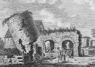
| Illustration
by S Hooper, 1783. It seems likely that this is the tower
mentioned below ( d
) |
|
|
|
|
|
|
|
|
|
|
|
|
|
|
|
|
TOWER
IN THE STREET LEADING FROM THE BRIDGE- By the time of Coxe's last
visit to Caerleon this tower had been taken down. Luckily he recorded
its presence and location for us, though not on the map. He said
it was situated in the street leading from the bridge and that
a public house, called 'The Gatehouse', marked its location. (d
on map probably). A
groove for a portcullis suggested that this could have been an
entrance to the castle. This view, drawn by S Hooper in 1778 and
published in 1783, may well show the tower.
CASTLE WALLS (e,
f, g and h on map).
Coxe indicated four places where the castle walls still stood.
Note that the wall at 'e' can still be seen (see present remains
- hyperlink).

[Back] [Caerleon
Castle Index] [Mynde Index]
[Home]
[History Index] [Search]
|
|
|
|
|