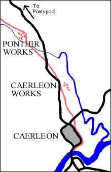
Caerleon Net
Home Page  Index  Search
Tramroad Index Page
Caerleon
Tramroad
Index page
When was it built?
Who built it?

Why was it built?
What did it look like?
What was its route?
What did it cost to build?
How was it operated?
When (and why) did it close?
What is left of it now?
How did it affect Caerleon?
References
tramroad
WHAT WAS ITS ROUTE?

The above illustration is based on a map published by Nathaniel Coltman in 1800. (Produced, we think, exclusively for Coxe's Historical Tour In Monmouthshre.) The map has been redrawn to make the routes of the tramroad and canal easier to follow. It shows that by 1800 a Rail Road (the Porth Mawr Tramroad) ran from Myndd Maen, where there was a colliery, down to the canal. After crossing the canal, it then joined the Caerleon Rail Road, which went right down to the River Usk in Caerleon. On its way it passed the Ponthir Tin Plate Works and the Caerleon Forge.
This is a section of a map by Moule, drawn in the late 1830s. The Porth Mawr Tramroad is not shown but the Caerleon Tramroad can be seen running from the Monmouthshire Canal right down to the River Usk.  The Ponthir Tin Works is indicated but the Caerleon Works is not - maybe the engraver did not want to clutter the map, this could also explain why the Ponthir Works appears to be the wrong side of the road and tramroad.
Llantarnam Abbey is also shown. It was near here that the milepost pictured on our index page was found.

The relative positions of road, tramroad and works are more accurately shown on the map to the right which is based on Prujean's map of 1843 entitled "Map of the Iron Works and Collieries and their Means of Communication by Railroad, Tramroad and Canal with the Ports of Newport and Cardiff".

The tramroad is indicated in red and the roads black. Both the Ponthir Works and Caerleon Works made use of water power from the River Afon Lwyd which runs down to join the River Usk at the foot of the map.